Technische Universität Darmstadt
Institute of Numerical Methods and Informatics in Civil Engineering
Prof. Dr.-Ing. Uwe Rüppel
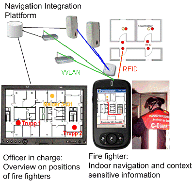
To save human lives and material assets complex buildings like airports are protected by automatic fire detectors. Within the normal operating state automatic fire detectors cause alarms, e.g., due to dust from reconstruction work or smoking people. The fire brigade of the Frankfurt Airport has about 5000 alarms per year. 95 per cent of them are so-called false alarms but in each case concentrated efforts of the fire brigade are necessary: Fire detectors and extinguishing systems have to be checked immediately. Building maps printed on paper are used by rescuers to find the fire protection systems within a building. Due to difficult orientation it often takes a long time to find automatic fire detectors. To support the search of the fire protection elements in a complex building and in general to improve disaster preparedness of fire brigades within the presented research project a system using mobile devices and different Real-Time Location Systems (RTLS) is developed. Networks for route calculation generated from BIM-data (Building Information Model) will guide the rescuer to the triggered fire detector. Additionally, important information, e. g., about sprinkler systems and dangerous goods, are displayed according to his position context-sensitive within the building.
Satellite navigation systems like GPS and Galileo (in the future) allow rotational position sensing within the accuracy of a few meters outdoor. Although signals will improve in the next few years, it might only be possible to detect positions in accuracy of a few meters directly under the roof of a building. On lower levels signals are absorbed by or reflected on walls and metal surfaces which prevent position sensing in an adequate precision. Therefore a new multi-method-approach combining WLAN, Radio Frequency Identification (RFID) and Ultra-Wide-Band (UWB) for indoor positioning purposes is developed. Based on this multi-method-approach the Indoor Navigation Integration Platform has been set up which stores the navigation data as well as the exported BIM-data (Fig. 1).
Further, the RFID navigation technology is used for the purpose of digital maintenance processes of fire safety objects in complex buildings. The presented RFID the research work is part of the German Workgroup ARGE- RFID (http://www.rfidimbau.de)
Further information can be found at http://www.iib.tu-darmstadt.de